

By Amanda Brend and Dan Lee
Thanks to funding from the North Isles Landscape Partnership Scheme (NILPS), a team from ORCA Archaeology (UHI Archaeology Institute) undertook geophysical survey for the Tombs of the Isles project at two suspected Neolithic tomb sites on the island of Sanday, Orkney in November 2022.

Despite driving rain and gales, the team successfully carried out the fieldwork at Whale Point (Whale Geo) and Ruthietaing on the north-west part of the island.
The aim was to establish more about the sites’ character, form and landscape context.
Two techniques were used, with magnetometer survey (good for identifying magnetically enhanced material from burning and settlement activity) and earth resistance survey (good for locating walls and structures) at Whale Point and magnetometer survey at Ruthietaing.
The site at Whale Point is recorded as a possible Neolithic chambered cairn and survives as a small mound surrounded by a ring of earth-fast boulders, measures c. 2m in diameter and up to 0.8m high.

Ruthietaing (Rethie Taing) is also recorded as a possible Neolithic chambered cairn. Visited by the then County Archaeologist Raymond Lamb in 1979, the site survived as a roughly semi-circular cairn of packed stones the east side of which lies next to the shore.
A length of well-built passage visible in the west portion of the mound led Lamb to interpret it as a chambered cairn of “Maeshowe-type”.
Whale Point
The magnetometer survey at Whale Point revealed a complex of features related to kelping activity, a common feature of the North Isles’ industrial past.

At least three of the features (Anomalies 1-3) are certainly kelp-pits while some of the others (Anomaly 4) may represent more deeply buried kelp-pits or material by-products of the kelping process.
The extant remnants of a probable kelp-drying wall are also visible in the survey area. The highly magnetic response of some of these features may mask other, more subtle traces of activity.
While there is no coherent magnetic signature from the mound thought to represent the tomb, this absence is only indicative of a lack of enhanced deposits and not a lack of archaeological remains.

Geophysical survey of other tomb sites in Orkney, for example, Roeberry, Hoy, produced similarly “quiet” results. In fact, the physical appearance of the mound with a possible stone kerb, may suggest that it represents the remains of a Bronze Age burial mound or barrow.
Further archaeological investigation would be required to establish more of the nature of the Whale Point site
Ruthietaing
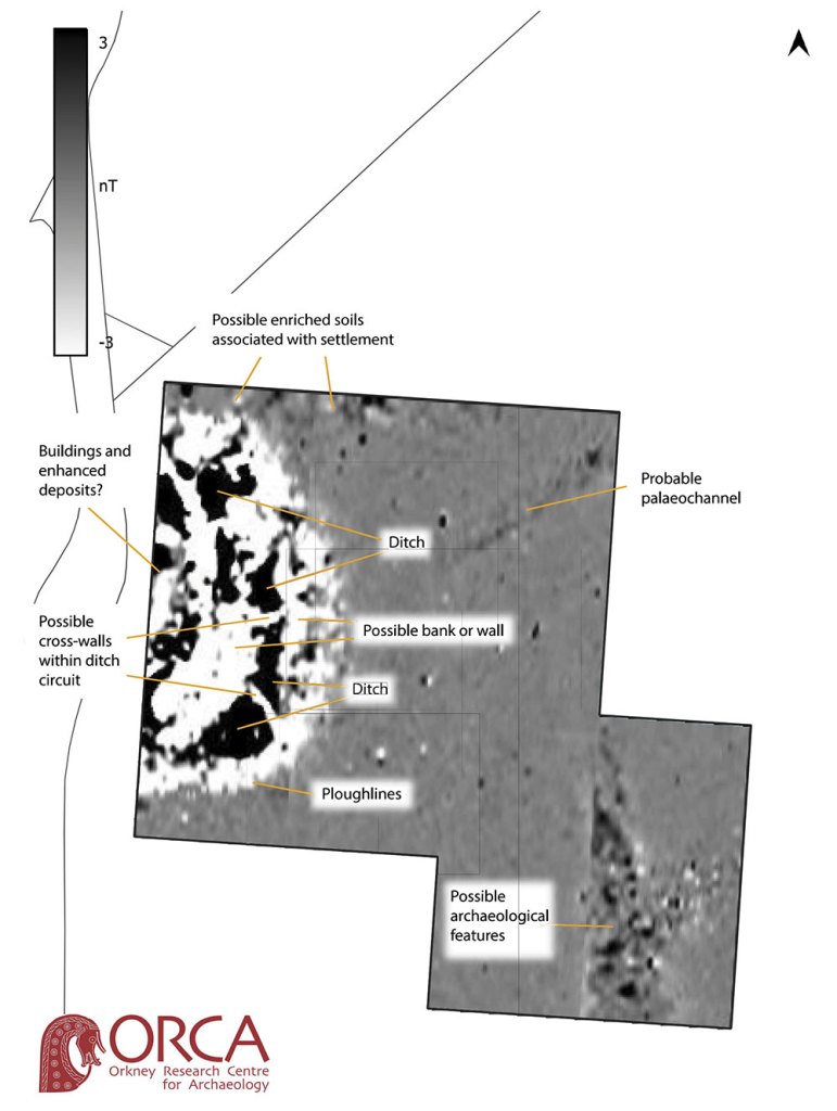
Magnetometer survey at Ruthietaing revealed the likely presence of a substantial prehistoric settlement on and extending beyond the mound. In both their scale and form, the geophysical responses suggest that the site is a prehistoric settlement, most probably an Iron Age broch or substantial roundhouse.
The anomalies show concentric walls/ramparts and ditch elements and bear a strong resemblance to survey of other later prehistoric settlements elsewhere in Orkney. While the results indicate the mound at Ruthietaing is not likely to be a Neolithic tomb, they have helped characterise this enigmatic site.

More geophysical surveys are planned for a number of tombs in the north isles of Orkney during 2023, watch this space!