(Rethie Taing, Ruthie Taing)

| Type: | Suggested to be Maeshowe-type. See geophysics note below. |
| Location: | Map |
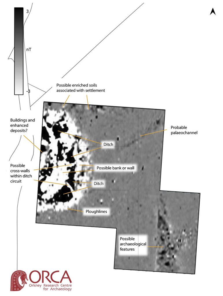
| Notes: | Although all records refer to this site as “Rethie Taing” the correct name for the headland is “Ruthie Taing” or “Ruthietaing”. To the north-east of the taing (Old Norse tangi – “tongue of land”) are the ruinous remains of a large mound, partially destroyed by coastal erosion. A shore dyke runs over the top. In 1979, county archaeologist Raymond Lamb had no doubt it was a Maeshowe-type cairn, at least 26m in diameter, with a section of a possible entrance passage visible on the western side and aligned ESE-WNW. Davidson & Henshall urged caution in interpreting very damaged sites such as Ruthietaing and did not include it in their inventory of Orcadian chambered cairns. [1] Nearby placenames suggest the mound may have been one of a number that have since been lost. The cairn sits in an area known as the Has o’ Meur, the first element of which may be a corruption of “Howes” – mounds. The adjacent field, Patie’s Hoose may also represent a corruption of the plural “Howes”. The placenames Yarrows and Knowes of Yarrows also suggest landscape mounds. [2] Update: November 2022 Magnetometer survey indicates the mound in unlikely to be a Neolithic chambered cairn. The results revealed the likely presence of a substantial prehistoric settlement on and extending beyond the mound. In both their scale and form, the geophysical responses suggest that the site is a prehistoric settlement, most probably an Iron Age broch or substantial roundhouse. The anomalies show concentric walls/ramparts and ditch elements and bear a strong resemblance to survey of other later prehistoric settlements elsewhere in Orkney. |
| Links: | Geophysical survey. November 2022 Canmore |
| References: | [1] Davidson, J. L. & Henshall, A. S. (1989). The Chambered Cairns of Orkney. Edinburgh: Edinburgh University Press. [2] Lamb, G. (1992) Naggles o Piapittem. Byrgisey. |